AIS (Automatic Identification System) transmissions are broadcasted over AIS radio frequences (VHF) without authentication or encryption. In the late 2000s, the International Maritime Organization (IMO), under the SOLAS Convention, mandated that all vessels of 300 GT or more trading in international waters must carry an AIS Class A system. Its purpose was to avoid collisions, make SAR operations more efficient, save the lives of seafarers, and protect values (cargo and vessels). The regulations entered into force on 1st of July 2002 for all newbuildings, and for all vessels of 300 GT or more operating in international waters by 1st of July 2008.
In addition to AIS Class A transponders, AIS Class B transponder exists as an aid for yachts, sailboats, fishing vessels and other smaller vessels not mandated to carry a Class A transponder.
Both Class A and Class B senders can be jammed or spoofed since it is the AIS protocol itself (and not the equipment) that is vulnerable.
AIS and GPS jamming
AIS jamming occurs when someone intentionally interferes with either the vessel’s GPS connection or the AIS protocol itself.
AIS jamming often comes “hand-in-hand” with GPS jamming. While AIS is for broadcasting vessels identity and position via VHF radio, GPS provide locations from satellites for devices with GPS transponders.
The GPS jamming is shown as location drifting and very inaccurate positions. The GPS jamming might also affect smartphones, drones, marine navigation systems, shore eqipments (in eg hospitals), telecom etc. While the AIS jamming don’t influence these systems.
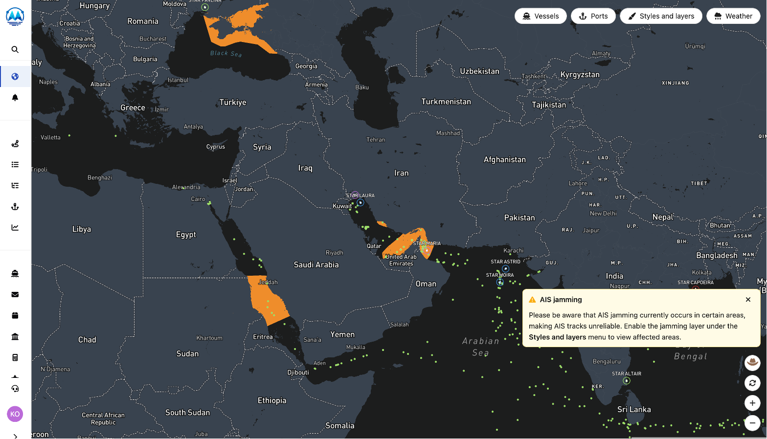
The result is that vessels broadcast incorrect positions, course, or speed. As an AIS provider, we most frequently observe AIS jamming in areas in conflict. Examples include, Crimea, Sea of Azov, Israel, and the Persian Gulf. Vessels might also experience jamming in certain areas that are not near areas in active conflict. Such examples include the ports of Vladivostok, Kaliningrad, St. Petersburg, and Murmansk.
There are several reasons why vessels might experience jamming. Near active conflict zones military forces may jam AIS to conceal naval movements or create uncertainty about maritime traffic. Vessels might also want to conceal their real operation. For example, when engaging in illegal fishing, cable cutting, or ship-to-ship transfers of sanctioned goods.
To inflict AIS jamming, one might interfere with the vessel’s own GPS connectivity by broadcasting strong electromagnetic waves in the corresponding frequency band. This can be combined with interfering directly with the VHF frequency band over which AIS messages are sent.
For vessels shown in ShipIntel the two cases are expressed slightly differently. In the case of GPS jamming, we receive AIS messages, but the position and speed are incorrect. In the case of VHF jamming, AIS messages are not received as the message itself is corrupted, leading to gaps in a vessel’s track. AIS jamming is blocking AIS signals and happens when someone transmits strong noise or interfering signals on the AIS radio frequencies (VHF), preventing legitimate AIS signals from being sent
The worst part about jamming is still the fact that it creates an increased risk of vessel collisions, and a reduced SAR capability for vessels in need of assistance.
How to detect AIS jamming
AIS jamming is often detected by companies processing raw AIS data like Maritime Optima. One indicator that jamming takes place is when multiple vessels disappear at the same time in the same area. Maritime Optima detects such occurrences and show them on the map.
Areas where AIS and GPS jamming are detected (screenshot from ShipIntel by Maritime Optima).
While the AIS jamming takes down the capability of monitoring maritime traffic, AIS jamming itself doesn’t necessarily influence the GPS (Global Positioning System) and navigation app using GPS, because the technology is different.
AIS jamming can takes place over a certain period of time and then it is put on hold, and then later the AIS jamming starts again. Very often it takes place in the same specific areas, and it repeats in the same areas over time.
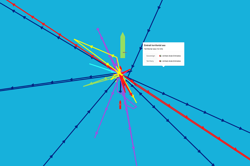
Another AIS jamming indicator is that the positions of a vessel “jump around” across large distances in a repetitive pattern. Often, jammed vessel positions might accumulate in certain “hot spots”, showing multiple vessels at the same position during the same time.
Such patterns are a sure-tell sign of GPS jamming. Maritime Optima automatically detect “hot spots” due to GPS jamming and adjust our ship-to-ship detection algorithm.
GPS Jamming (screenshot from ShipIntel by Maritime Optima).
AIS spoofing
AIS spoofing is when a vessel purposely transmits AIS messages incorrectly, to mask its real position or create an altered identity. It does not impact other vessels. Spoofing can take the form of replaying an older track, or broadcasting positions in a circle.
Spoofing may be achieved by specific software installed onboard the vessel, programming a software- defined radio to transmit AIS signals, or by modifying an existing AIS transponder. AIS spoofing might create “ghost vessels”, false tracks, show a ship's position in a restricted area or multiple tracks for one vessel.
GPS spoofing (screenshot from ShipIntel by Maritime Optima).
The importance of processing the raw AIS data in-house
At Maritime Optima, we have chosen to process raw AIS data in-house rather than purchasing pre-processed datasets to be able to quickly and continuously improve the datasets.
We subscribe to raw AIS streams from satellites, terrestrial receivers, and dynamic sources onboard vessels. Processing this data involves collecting, decoding, analyzing, and enriching it with additional maritime information within our AIS pipeline. The resulting data supports a wide range of features and insights related to vessels, voyage tracking, market intelligence, and business insight.
We offer two software products:
ShipAtlas for individuals interested in tracking vessels.
ShipIntel for companies involved in maritime business.
ShipIntel Essentials is an AI-powered maritime decision support system for any type of company involved in maritime business, helping reduce manual work, create more business and provide better service based on data-driven insights.
If you would like to learn more about our offerings, please reach out to us!